Day 5 of 5
Got up at 6:00 a.m. to intense mosquitoes. I wore the bug jacket for the first time this trip. We were up early to get some distance before a potentially windy afternoon — and to give us the option of staying at a hotel in La Ronge if we didn’t end up windbound.

An early breakfast at our convenient rock table (6:50 a.m.). Convenient, provided you didn’t knock anything into the lake!
We were on the water by 8:30 a.m.
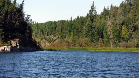
Small bay NW of the campsite (campsite on the rock outcropping on the left)
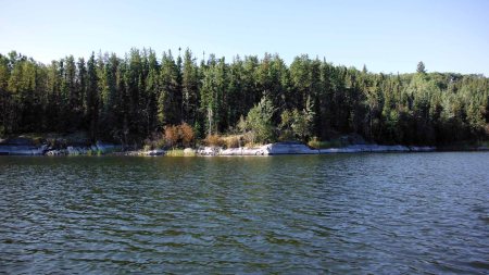
Campsite on the rocky area in the center of the photo
We had some concerns about paddling upstream through the narrow section with strong current upstream of McMorris Bay, but we easily managed the 5 minutes of strong, steady paddling that was required to get through.
We stopped to fuel up and relieve ourselves at a point before crossing Drope Lake. We attempted to scout the size of the waves on the lake from the point before embarking on the crossing. From this vantage the crossing looked feasible.
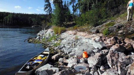
Taking a rest stop before tackling the Drope Lake crossing (9:50 a.m.)
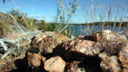
Rose Quartz

Scouting the Drope Lake crossing. You can’t see the waves much from this angle or resolution.
There was a strong WSW wind blowing across Drope Lake. Just like with the first crossing, we used the south shore and islands for protection. We started the crossing at 10 a.m. The wind was steady, pushing us to ~70 to 80% of our maximum wind/wave tolerance for a lake crossing. There was the occasional small white caps forming and splash of water into the boat.
Passing by an island 400 m SE from the wider set of Stanley Rapids, we noted water currents pushing upward from deep below near the island shore. We figured out this was from underwater currents created by the rapids, which surprised us considering the distance of relatively calm water between the island and the rapids. It gave a sense of the immense depth of the lake. By this time we were relatively sheltered from the wind and could relax again.
We ate a lunch of nan bread with PB + jam at the Stanley Rapids portage from 11:30 to 12. We watched otters portaging the rapids on the opposite NE shore — a first for both of us ever seeing otters in the wild. Tiny crayfish moving in and out of the submerged plants in the water also provided lunch time entertainment.
We faced a very strong headwind entering the next unnamed lake. When we rounded a point directly into the wind, it took most of our effort to brace and pry to keep the boat upright and perpendicular to the waves. We quickly realized we were outdone, so we allowed the wind to blow us backwards so we could maneouver into a sheltered bay to wait for the wind to die down (at about 12:30 p.m.). To pass the time we took a washroom break, nap, blueberry picking, tricky fire starting in windy conditions with limited convenient dead wood available, cooked an early supper of dehydrated veggies and Lipton soup (which turned out to be a delicious combination).
We were back on the water at 4:30 p.m. By now the wind was much less, but there was still WSW wind gusts. Then after a half hour or so we made it to the opposite shore which was protected. Then the wind died down for the day soon after.
We took in each site and sound with sensory volumes turned up and a reflective, sentimental reverence, knowing the trip was ending soon. I concluded that the northern Canadian Shield remained a favourite paddling paradise for me, just as awe inspiring and incredible as my last canoe trip here 20 years ago.
We decided to aim for a night at a hotel in La Ronge rather than camp another night. Once we started thinking about a shower/bath, comfy beds for sore muscles, etc., our minds were made up. Plus it would be nice to break up the long drive back over an additional day.

We arrived at Stanley Mission at 5:45 p.m. We packed up and were driving by 6:30 p.m. The sun was setting through the trees creating a mood suitable to the bittersweet end of the trip. Each mysterious, winding side trail winding, with shafts of orange sunlight filtering through the trees, whispered alluring invitations that promised a lifetimes worth of future adventures of exploration.
Slowly breaking out of the spell, we arrived at the Waterbase Inn by 8:30 p.m., after texting a friend from the area for advice on which place to stay at. It was a very well kempt motel/float plane airport. We luxuriated in a shower for me and bath for Sarah, and the comfy bed.
Epilogue: August 21, 2015 – Driving Home
The next morning we visited a quaint shop (Robertson Trading Co.) across the street, full of interesting wares, where we bought locally harvested wild rice. Sarah bought an ammolite stone necklace as a souvenir of our trip. After lingering for a while, we departed on the long drive back to Rosetown.
On the way to Rosetown we took a break just north of Prince Albert to hike the “Little Red” forested area. I had spent a lot of time hiking and cross-country skiing in this area while living and working for a year in Prince Albert over a decade ago. My memory was less useful than I anticipated in navigating the area — it’s full of random trails crisscrossing in all directions.
Knowing we had phone reception and online maps if needed, we decided to take whatever random trails fancied us, then attempt to find our way back without the maps as much as possible. It was a cloudy day, so I got very confused and turned around. We eventually hit a dead end at a creek and finally resorted to checking the online map.
We were very close to our parked car, but because of the creek we had to back-track a long way around, in a much different direction than we thought. It was very fun adventure to end the trip with, and yet a humbling reminder of how easy it is to get lost. One of these days I will need to work on brushing up on my compass navigation skills.
While at Rosetown I made it out on a few cycling rides along the rural roads outside of town.

Banded Garden Spider discovered beside me in the grass while I was taking a break from cycling along a country road west of Rosetown
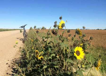
Prairie Sunflower west of Rosetown
